Spatial Join
Spatial Join⚓︎
This page explains how to use the Spatial Join job to perform a spatial join operation between two datasets.
Function⚓︎
Performs a spatial join operation between two datasets within the TDEI system. It involves two datasets - target and source - specifying the spatial dimension entities of each to be joined (e.g., edge, node, zone, point, line, polygon). The join operation is guided by specified conditions that define how the geometries of the two datasets interact, typically involving spatial functions like intersections. Filters can be applied to both datasets to refine the data involved in the join. Aggregate functions are also defined to associate attributes from the source to the target dataset entity. The geometry columns for data elements are referenced as geometry_target and geometry_source.
Example: Find all light poles in a source dataset within 5 m of an edge in a target dataset, and associate the highway attribute from the source dataset with each edge.
Job Creation Form⚓︎
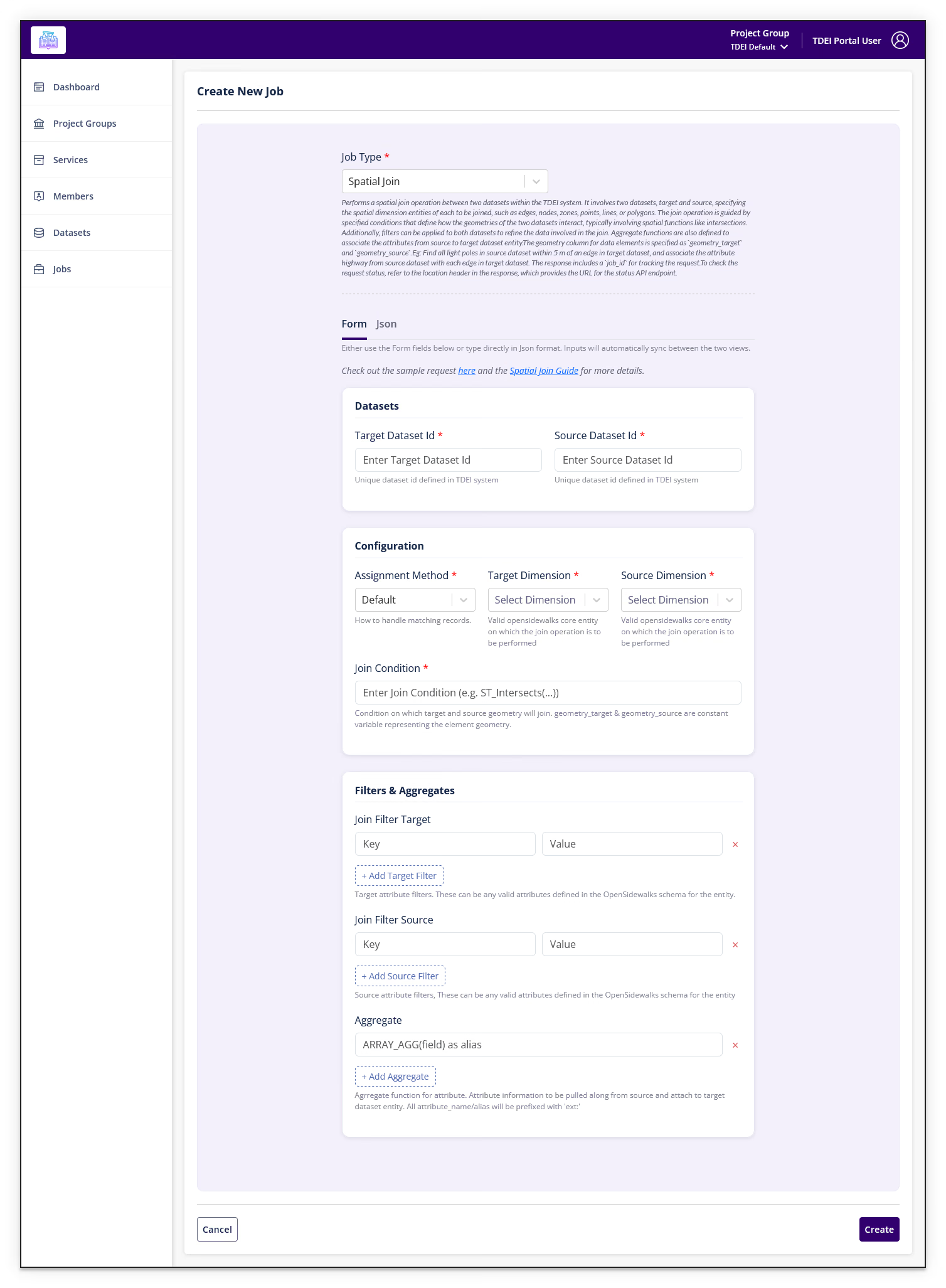
The form contains a JSON text area pre-populated with the following template:
{
    "target_dataset_id": "",
    "target_dimension": "",
    "source_dataset_id": "",
    "source_dimension": "",
    "join_condition": "",
    "join_filter_target": "",
    "join_filter_source": "",
    "aggregate": []
}
A link labeled "(hint: check out the sample request here)" is available below the text area. Selecting it opens a Sample Request Body dialog with a copy button and an Assignment Method dropdown to switch between Default and Exclusive examples.
Assignment Methods⚓︎
The request body supports two assignment methods:
Default (no assignment_method field required):
{
    "target_dataset_id": "fa8e12ea-6b0c-4d3e-8b38-5b87b268e76b",
    "target_dimension": "edge",
    "source_dataset_id": "0d661b69495d47fb838862edf699fe09",
    "source_dimension": "point",
    "join_condition": "ST_Intersects(ST_Buffer(geometry_target, 5), geometry_source)",
    "join_filter_target": "highway='footway' AND footway='sidewalk'",
    "join_filter_source": "highway='street_lamp'",
    "aggregate": ["ARRAY_AGG(highway) as lamps"]
}
Exclusive (adds "assignment_method": "exclusive"):
{
    "target_dataset_id": "fa8e12ea-6b0c-4d3e-8b38-5b87b268e76b",
    "target_dimension": "edge",
    "source_dataset_id": "0d661b69495d47fb838862edf699fe09",
    "source_dimension": "point",
    "join_condition": "ST_Intersects(ST_Buffer(geometry_target, 5), geometry_source)",
    "join_filter_target": "highway='footway' AND footway='sidewalk'",
    "join_filter_source": "highway='street_lamp'",
    "aggregate": ["ARRAY_AGG(highway) as lamps"],
    "assignment_method": "exclusive"
}
Full job description
Performs a spatial join operation between two datasets within the TDEI system.
It involves two datasets, target and source, specifying the spatial dimension entities of each to be joined, such as edges, nodes, zones, points, lines, or polygons.
The join operation is guided by specified conditions that define how the geometries of the two datasets interact, typically involving spatial functions like intersections.
Additionally, filters can be applied to both datasets to refine the data involved in the join.
Aggregate functions are also defined to associate the attributes from source to target dataset entity.
The geometry column for data elements is specified as geometry_target and geometry_source.
Eg: Find all light poles in source dataset within 5 m of an edge in target dataset, and associate the attribute highway from source dataset with each edge in target dataset.
The response includes a job_id for tracking the request.
To check the request status, refer to the location header in the response, which provides the URL for the status API endpoint.
Select Create to submit the job. Select Cancel to return to the Jobs list.
OSW Spatial Join – Guide⚓︎
This section explains how to use /api/v1/osw/spatial-join from an API or UI perspective, with concrete OSW sidewalk and pedestrian data examples that show how to pick the right assignment_method (default, exclusive, shared) and how to structure JSON requests for common real-world scenarios like curb ramps, light poles, and intersections.
Understanding the spatial-join Job Input⚓︎
- Target dataset (
target_dataset_id,target_dimension):
OSW dataset whose features you want to enrich (e.g., sidewalk edges or nodes). - Source dataset (
source_dataset_id,source_dimension):
OSW dataset that provides attributes (e.g., curb ramps, lighting, crossings, entrances). - Join condition (
join_condition):
Spatial condition usinggeometry_targetandgeometry_source(e.g., within 5 m, intersects). - Filters (
join_filter_target,join_filter_source):
Attribute filters on each side to narrow which features participate. - Aggregates (
aggregate):
How attributes from the source are collected and attached to each target feature. - Assignment method (
assignment_method):
How to resolve multiple matches between targets and sources.
What is assignment_method?⚓︎
"assignment_method": "default" | "exclusive" | "shared"
default: many-to-many – each target keeps all matching source features.exclusive: one-to-one – each target gets at most one source, and each source is assigned to at most one target (competitive closest assignment).shared: one-to-many – each target gets its best (closest) source, but a source may be shared by many targets.
Choose the method based on the real-world relationship between the two datasets, not just what is technically possible.
When to use which method⚓︎
default – exploration and statistics (many-to-many)⚓︎
Use when
- You want all nearby matches, not just the best one.
- It is fine for one physical object (power pole, street lamp, intersection etc) to be attached to many sidewalk features.
- You are doing exploratory analysis, QA, or generating statistics.
Typical OSW example – all light poles near sidewalks
For each sidewalk edge, list all light poles that lie within 4 m of the edge, and only along the “middle” of the edge (between 20% and 90% of its length), then attach detailed pole attributes.
{
    "target_dataset_id": "791a65c8-2887-4df4-b624-7ebe5a4d30d0",
    "target_dimension": "edge",
    "source_dataset_id": "018c3608-0520-4dec-a625-b3942711ebfe",
    "source_dimension": "node",
    "join_condition": "ST_DWithin(geometry_target, geometry_source, 4) AND (ST_LineLocatePoint(geometry_target, geometry_source) BETWEEN 0.2 AND 0.9)",
    "join_filter_target": "",
    "join_filter_source": "",
    "aggregate": [
        "ARRAY_AGG(ext:unit_id) as SDOT_pole_unit_id",
        "ARRAY_AGG(ext:subtypecd) as SDOT_subtypecd",
        "ARRAY_AGG(ext:pole_height) as SDOT_pole_height",
        "ARRAY_AGG(ext:pole_asset_id) as SDOT_pole_asset_id",
        "ARRAY_AGG(ext:pole_HasStreetlight) as SDOT_pole_HasStreetlight"
    ],
    "assignment_method": "default"
}
How to interpret
- Each sidewalk edge will have arrays listing all poles that are close to that edge and fall along the interior (20–90%) of the edge geometry.
- The same physical pole may appear under multiple edges if it is close enough to more than one edge.
Use default when your question is roughly: “What exists around each feature?”
exclusive – strict one-to-one assignments⚓︎
Use when
- You need a clean 1–1 mapping between datasets:
- Each curb ramp must belong to one sidewalk edge or crossing.
- Each target should not share a source that another target also owns.
- You are building a routing or network model and want to avoid double-counting sources.
Typical OSW example – assign each curb ramp to a single best sidewalk node
For each curb ramp node, choose exactly one “host” sidewalk node with
barrier='kerb'within 4 m; avoid assigning the same ramp to multiple nodes.
{
    "target_dataset_id": "52945d79-a0df-4440-8363-73bea8e1882a",
    "target_dimension": "node",
    "source_dataset_id": "d286d472-52c3-481b-bf74-a1289091a422",
    "source_dimension": "node",
    "join_condition": "ST_DWithin(geometry_target, geometry_source, 4)",
    "join_filter_target": "barrier='kerb'",
    "join_filter_source": "barrier='kerb'",
    "aggregate": [
        "ARRAY_AGG(_id) as SDOT_curb_ramp_id",
        "ARRAY_AGG(ext:unit_id) as SDOT_curb_ramp_unit_id",
        "ARRAY_AGG(ext:ramp_width_mt) as SDOT_curb_ramp_width"
    ],
    "assignment_method": "exclusive"
}
How to interpret
- Each sidewalk node with
barrier='kerb'will have attributes derived from at most one ramp node. - Each ramp node is assigned to at most one sidewalk node.
Use exclusive when your question is roughly: “Who is the single owner/host of this feature?”
shared – shared infrastructure (one-to-many)⚓︎
Use when
- Each target should pick its best source (usually the closest).
- It is realistic for the same physical object to serve multiple targets:
- One curb ramp provides access to several nearby edges.
- You want just one chosen source per target, but allow reuse of that source.
Typical OSW example – each intersection node gets its nearest intersection record, intersections can be shared
For each node in the sidewalk network representing an intersection, attach information from the nearest intersection record (within 20 m). The same intersection record may serve multiple sidewalks.
{
    "target_dataset_id": "7deb13ce-8af7-4198-98c7-b63fd66def10",
    "target_dimension": "edge",
    "source_dataset_id": "f46995c3-0947-41b1-a2f3-3ca2d4dbf65e",
    "source_dimension": "node",
    "join_condition": "ST_DWithin(geometry_target, geometry_source, 20)",
    "join_filter_target": "",
    "join_filter_source": "",
    "aggregate": [
        "ARRAY_AGG(_id) as intersection_id",
        "ARRAY_AGG(ext:unitdesc) as intersection_unit_desc"
    ],
    "assignment_method": "shared"
}
How to interpret
- Each target sidewalk is linked to the closest intersection record (if any).
- The same intersection record can be the chosen record for many different sidewalks.
Use shared when your question is roughly: “What is the main facility or record serving this location, even if it serves others too?”
Composing your own spatial joins⚓︎
When building a new request, think in three steps:
-
Choose datasets and dimensions
- Target (
target_dataset_id,target_dimension): what you want to enrich (e.g.,edge,node,zone). - Source (
source_dataset_id,source_dimension): what provides attributes (e.g.,pointfor ramps,polygonfor buildings,edgefor network-to-network).
- Target (
-
Define spatial relationship and filters
join_conditionexamples:"ST_DWithin(geometry_target, geometry_source, 5)"– within 5 m."ST_Intersects(ST_Buffer(geometry_target, 2), geometry_source)"– within a corridor around an edge.
join_filter_target/join_filter_sourceexamples:"highway='footway' AND footway='sidewalk'","barrier='kerb'","highway='street_lamp'","amenity='bench'".
-
Define aggregates and assignment method
aggregateexamples:"ARRAY_AGG(highway) as lamps","min(ramp_width_mt) as min_ramp_width","count(*) as ramp_count".
assignment_method:default– keep all matching sources (exploration, statistics, QA).exclusive– enforce one-to-one relationships (strict network models).shared– pick one best source per target but allow sources to be reused (shared facilities).
By combining above these input parts, you can compose your own spatial joins tailored to OSW sidewalk and pedestrian accessibility use cases.
Return to Jobs.